Insurance and Disaster Assessment
When a storm hits, a roof collapses, or a structure is damaged, the clock starts immediately. Insurance adjusters need documentation. Contractors need to assess scope. Property owners need to understand what they're dealing with — and in some cases, what they need to do right now to prevent further damage. Drone photography delivers all of that faster, more safely, and more completely than any ground-based inspection can.
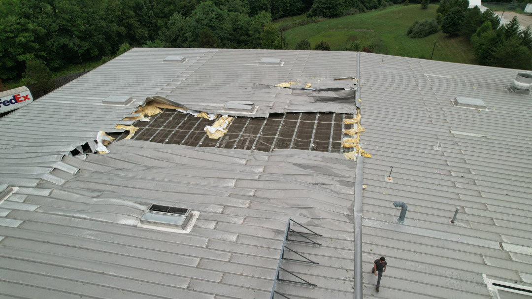
The day after a severe storm tore the roof off a large commercial distribution facility in Northeast Ohio, Ed Rich was on site with a drone. The client needed two things immediately: comprehensive photographic documentation of the damage for the insurance claim, and a detailed aerial assessment of the roof surface to determine what areas needed emergency tarping to prevent water intrusion. A single flight delivered both — high-resolution stills covering the entire roof from multiple angles, processed and delivered within 4 hours of the call. Ed Rich was on site within 90 minutes of being contacted. The aerial view identified damage patterns and vulnerable areas that a ground inspection would have missed entirely.
Insurance claims are stronger when documentation is captured immediately after an event — before emergency repairs alter the scene, before weather causes secondary damage, and before the full extent of the loss becomes disputed. For urgent situations, Ed Rich can mobilize rapidly — on site within 90 minutes and edited imagery delivered within hours, not days. Emergency response is available for Northeast Ohio properties at priority rates.
What Drone Documentation Does That Traditional Inspection Can't
A drone can photograph every square foot of a commercial roof systematically — ridgelines, valleys, flashings, penetrations, and perimeter edges — in a fraction of the time it takes an inspector to walk the surface, without putting anyone on a damaged or potentially unstable structure.
Storm-damaged structures can be structurally compromised, making physical access dangerous. A drone documents the damage without requiring anyone to climb, enter, or stand beneath an unstable roof, wall, or structure. The inspector stays safe on the ground while the aerial camera does the work.
High-resolution RAW imagery captured by a licensed, insured operator carries significantly more weight in a claims process than smartphone photos or contractor estimates. Date-stamped, professionally shot aerial documentation establishes the condition of the property at a specific point in time — before any repairs begin.
Beyond documentation, aerial photography informs immediate decisions — where to deploy tarps, which areas need shoring, what equipment access points exist. A single aerial flight can replace hours of ground-level assessment and deliver actionable information to contractors and emergency responders faster.
Industrial facilities, warehouse complexes, and multi-building commercial properties cover ground that's impractical to document thoroughly on foot. Drone photography covers large sites quickly and systematically, ensuring nothing is missed — critical when the extent of storm or disaster damage isn't immediately obvious from the ground.
For properties with prior aerial photography on file, post-event drone imagery creates a direct before-and-after comparison that clearly establishes the extent of the loss. For construction and commercial clients with ongoing aerial documentation programs, this record is already in place when they need it most.
Who Calls NE Ohio Drone for Damage Documentation
- Insurance adjusters and claims professionals Faster, more complete documentation means faster, more defensible claim settlements. Aerial imagery from a licensed operator supports accurate estimates and reduces disputes.
- Commercial property owners and managers When you need to know the full extent of the damage before your contractor tells you — and before your insurer disputes the scope — independent aerial documentation protects your position.
- Roofing and restoration contractors Pre-repair aerial documentation protects contractors from liability disputes. Post-repair imagery confirms the completed scope of work.
- Commercial real estate attorneys and risk managers Timestamped aerial imagery from a licensed, insured operator is credible documentation in legal and regulatory proceedings.
For storm damage, roof inspections, and emergency documentation in Northeast Ohio — don't wait. For emergency situations, Ed Rich can be on site within 90 minutes. Standard response within 24 hours.