Aerial Mapping & Site Documentation
Aerial Mapping & Site Documentation for Northeast Ohio & Western PA
Some jobs aren't about a single great photo or video. They're about clear, repeatable aerial documentation that helps businesses monitor properties, track site conditions over time, and maintain reliable visual records. That's exactly what NE Ohio Drone delivers with professional orthomosaic aerial mapping services.
What Is an Orthomosaic Map?
An orthomosaic map is a single high-resolution aerial image created by stitching together hundreds of overlapping drone photographs using professional photogrammetry software. The final result is a geo-referenced bird’s-eye view of your entire property or job site that can be viewed, shared, and used inside GIS and mapping platforms.
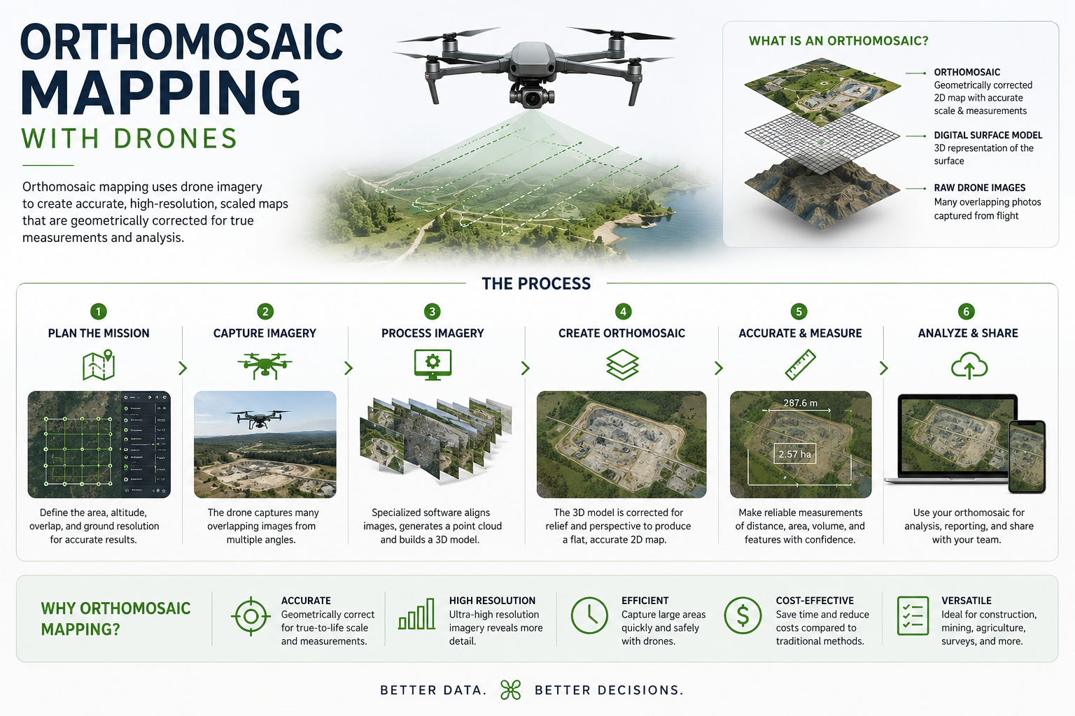
Orthomosaic maps are ideal for documenting site conditions, tracking project progress, monitoring outdoor inventory and equipment, and maintaining a reliable visual record over time. Compared to standard aerial photography or satellite imagery, they provide significantly more detail and a current view of your site.
Maps are intended for visualization, planning, documentation, and general measurement purposes and are not a replacement for licensed land surveying services.
Who Needs This Service?
This service is built for companies that manage, monitor, or document large outdoor properties and operational areas where reliable aerial visuals provide operational and financial value.
Track materials, equipment, and project progress across large job sites with detailed aerial overviews that are easy to compare over time.
Document facilities, storage yards, and operational sites with current aerial imagery for planning and internal reporting.
Maintain a visual inventory record of equipment placement and site organization across large properties.
Create before-and-after aerial records for claims support, storm documentation, and property condition reporting.
Maintain consistent aerial records for compliance, planning, inspections, and operational documentation.
Monitor large properties, development projects, and outdoor assets with detailed overhead imagery.
How It Works
We review your property, plan the flight path for complete coverage, and handle any required FAA airspace authorizations before the mission begins.
We fly a planned aerial grid pattern over the site, capturing a large series of overlapping high-resolution images. This overlap allows the software to seamlessly stitch the images into one detailed aerial map with consistent coverage across the property.
Images are processed using professional photogrammetry software to create a seamless, geo-referenced orthomosaic image of the site. The final deliverable is aligned to real-world coordinates and suitable for documentation, planning, site visualization, and general GIS use.
Your final map is delivered digitally in GeoTIFF, high-resolution JPEG, or another compatible format for easy viewing, sharing, archiving, or GIS integration.
Image quality and visibility may be affected by weather conditions, seasonal vegetation, shadows, or site access limitations.
Recurring Site Documentation Programs
For clients who need ongoing aerial documentation, NE Ohio Drone offers monthly and quarterly flyover programs using consistent flight paths and repeatable capture methods. These recurring services help operations teams, project managers, and property owners maintain a dependable visual history of their sites over time.
Deliverable Formats
GeoTIFF — A geo-referenced image format compatible with GIS (Geographic Information System) platforms including ArcGIS and QGIS. These files are useful for site visualization, general measurements, progress tracking, documentation, and historical comparison over time.
High-Resolution JPEG — Ideal for reports, presentations, inspections, insurance documentation, internal records, and day-to-day operational use.
If your team uses a specific platform or workflow, ask us — we’ll do our best to provide a compatible deliverable format.
Request a Quote
Tell us about your property, project, or documentation needs and we’ll get back to you promptly.
📞 (330) 208-3601 ✉ NEOhioDrone@gmail.comFAA Part 107 Licensed · $1 Million Liability Insurance · Serving Northeast Ohio & Western Pennsylvania
"Clear aerial documentation. Reliable results. Professional service."
— Ed Rich, NE Ohio Drone LLC
